
WG3: Realizing synergy between passive EO spectral domains
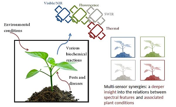
Plants respond to changing environmental conditions with various biochemical reactions that influence the passive remote sensing signal in different domains. However, most studies in satellite EO of vegetation make use of only one single sensor. Multi-sensor or synergistic sensor use will provide a deeper insight into the relations between spectral features and associated plant conditions. This Working Group aims to help realize synergies between passive optical EO domains. As multi-sensor approaches are typically affected by associated differences in spatial and temporal characteristics and vice versa, the achievements in the closing of the scaling gap (WG1) and temporal gap (WG2) will be of fundamental importance to WG3.
The first meeting of WG-3 is on FEB 05 2019 in Brno.
One important outcome of the first meeting was a literature review from Marlena and a database collection from Corine, which we would like to further complete. Thus, we would like to invite you to add further relevant information to the documents.
Literature review: https://docs.google.com/spreadsheets/d/1caU9U0pqZ3RwNe1HvEtrGeBUA4sVWn5qHFQSV7kTvYs/edit#gid=0
Sensor synergies database: https://docs.google.com/document/d/1ew7KOvhd8dW1L2zsXiY-AMNL8e90i2EEwbPZUxP916M/edit?usp=sharing
An overview on the exisiting protocols for vegetation monitoring was created by Laura Mihai and which is availabe here.
Veronica and Maria Luisa prepared a survey which was sent to commercial stakeholders. The aim of this survey was to find out the needs of companies where research or in concrete Senseco can collaborate to find solutions. The summary of the survey outcome can be found here.
Working group 3 "sensor synergies" organised jointly with colleagues from the Emphasis network a virtual workshop on the 10th FEB 2021. Aim was the identification of cutting edge topics to foster future collaborations and to develop new ideas and new concepts by bringing the two communities together. For instance, remote sensing and phenotyping communities use the same sensor technologies (hyperspectral, thermal, fluorescence, 3-D, etc.) and need similar retrieval methods, but work on different scales with overlap at the field- and UAV-platform levels and target different applications (e.g. precision agriculture vs. phenotyping). Thus, we brought experts from the remote sensing and plant phenotyping communities together to exchange and discuss where are common interests and synergy effects. Mainly, the focus was led on the assessment of vegetation properties and crop stress and disease detection using synergies from both communities and, ultimately, to develop a strategy to work closer together. 139 researcher attended the workshop which was divided into two parts. First, four talks on cutting edge topics from both communities were presented and discussed. The presentations are available here:
•Martin Schlerf (LIST Luxembourg): “Remote sensing of vegetation – some claims on selected traits.”
•Roland Pieruschka (FZ Jülich, Germany): “Phenotyping for crop improvement - technologies - access – knowledge.”
•Frederic Baret (INRA, Avignon, France): “From satellite remote sensing to close range phenotyping: a revolution in traits accessible, data volume and interpretation methods”
•Jose Jimenez-Berni (Institute for Sustainable Agriculture, Spanish National Research Council – CSIC, Cordoba, Spain): “Field Phenomics beyond crop breeding: exploring the interception between remote sensing and crop physiology.”
The second part was an open discussion led by Uwe Rascher on the intersections of both communities and on unsolved questions which are of interest for both.
For us, the organising team, the high interest, the large number of participants and the feedback after the workshop outreached by far our expectations and we are looking forward to more events which may follow the coming month!!
Thank you all!
Uwe Rascher (FZ Jülich, Germany), Katja Berger (LMU, Germany), Sven Fahrner (FZ Jülich, Germany), Miriam Machwitz (LIST, Luxembourg), Roland Pieruschka (FZ Jülich, Germany) & Martin Schlerf (LIST Luxembourg) (order according to the picture)

Working group 3 had a very successful workshop in Cesis, Lavia. The program was a mixture of scientific talks, an excursion to the Institute for Environmental Solutions and practical work and planning.
Talks were focusing on the acquisition and combination of different datasets from different spectral domains. Main focus was on stressed vegetation in agriculture followed by active discussions.
We had the chance to visit the facilities of the Institute for Environmental Solutions with its fleet of aircrafts, different multi- and hyperspectral sensors, laboratories and test fields. The group could get in touch with the management and researchers and got insights into their work. Thank you for the great opportunity and organisation!
In the second part of the workshop we planned the next events like the MC meeting, summer school and a workshop with the phenotyping community. Furthermore, we worked on a common review paper, which shall be written the next month.


Participants: Maria Luisa Buchaillot (LO, University of Barcelona), Etienne David (HiPhen Plant, France), Jose A. Jimenez-Berni (IAS-CSIC, Cordoba, Spain), Shawn Kefauver (LO, University of Barcelona), Eyup Selim Koksal (Ondokuz Mayıs University, Samsun/Turkey), Miriam Machwitz (LIST, Luxembourg), Egor Prikaziuk (University of Twente, Netherlands), Offer Rozenstein (Agricultural Research Organization - Volcani Institute, Israel), Martin Schlerf (LIST, Luxembourg), Veronica Sobejano Paz (Aerial Tools, Denmark), Esra Tunc Gormus (KTU, Turkey), Emre Tunca (Ondokuz Mayıs University, Samsun/Turkey), Zaib un Nisa (Uni Molise, Italy), Florian Werner (Hydrosat, Luxembourg), Carlos Ferraz (HEMAV, Spain)
In March 2022 we had a workshop in Barcelona with talks on different examples for sensor synergies, preparation of the guidelines (deliverable WG3), exchange with stakeholders/private companies and planning of a COST follow-up proposal from the perspective of WG3.
All the talks were followed by a very living discussion and many points came up related to sensor synergies and related challenges, problems and solutions (program can be found here). For example, we had surveys and discussions on the role of different spectral domains for different traits, the role of lidar and SAR, and challenges with thermal data. Overall talks it was stated that there is an advantage to using sensors from different spectral domains but at the same time leading to issues that need to be considered. Furthermore, the review paper which was written within WG3 and led by Katja, was presented and (by chance) submitted during the workshop.
With a breakout group, we worked on the guideline preparation for WG3. We collected examples, problems, challenges to be respected and discussed solutions. However, the guideline preparation still needs to be finalized.
A second breakout group prepared the round table discussion with stakeholders which took place on the second day. This part of the workshop was opened by a presentation on a survey in which 14 different companies of remote sensing in agriculture around Europe were answered. These surveys were done by Maria Luisa and Veronica. The outcome of this survey is also available on the Senseco Webpage. Afterward, each company was presented by its representatives (Veronica, Carlos, Florian, Etienne). The presentations were followed by a very good and living round table discussion. The discussion was focused on better collaboration between Senseco, research, and companies as well as on the role of companies and future collaborations options with respect to a follow-up COST action. A detailed document on the outcomings of the round table discussion can be found here.
Objective 3.1 To provide homogenized protocols and methods for synergistic use of multi-sensor approaches.
Objective 3.2 Using improved RTMs (Objective 1.3), to translate integrated multi-sensor and acrossspectral domain approaches into enhanced RS-based capacities for monitoring vegetation responses to environmental changes (Objective 4.4).
Objective 3.3 To provide guidelines on how multiple sensors can best be used for assessing crop water and nutrient requirements in order to help agricultural managers and other stakeholders (e.g. deficit irrigation, nitrogen fertilization) and to increase the socio-economic impact of EO data.
Task 3.1 Workshop (end of year 1). Aim: To discuss achievements and problems and best practice solutions in the characterization of plant condition and stress from multi-sensor use in agriculture. The Workshop will be divided into two parts. The first part will bring together different stakeholders like farmers, environmental and agricultural governmental representatives, instrument manufacturers and insurance companies to analyse the needs and problems of all parties. The second part will be attended by researchers only to consider and implement the outcomes of part 1. Output: protocols.
Task 3.2 Workshop (year 2). Aim: Discuss challenges and suggest solutions for multi-sensor synergy for vegetation attribute retrieval through inverse methods (jointly with WG-1). Output: guidelines.
Task 3.3 Training school (year 3) on synergistic optical data use; modellers and experimental scientists in the field will use measured and simulated sensor data to progress towards a more holistic multi-scale approach.
Deliverable 3.1 Best practice protocols for the detection and characterization of different stresses at different phenological stages. Berger et al., 2022
Deliverable 3.2 Guidelines for vegetation attribute retrieval through RTM inversion schemes. These objectives will be supported by existing ground and airborne dataset of hyperspectral data that have been collected in the VNIR (e.g., HyPlant), TIR (e.g., Hyper-Cam LW) within dedicated campaigns (e.g. FLEX campaigns or multi-sensor airborne platform operated for instance by CzechGlobe, Hanuš et al. 2016) at different sites in Europe. Machwitz et al., 2021
Leading Team WG-3
 Dr Miriam Machwitz (leader), LIST, Luxembourg, miriam.machwitz@list.lu
Miriam has a background in environmental sciences and obtained her PhD in Remote Sensing. She is working as a Research Associate at the Luxembourg Institute of Science and Technology (LIST) focusing on vegetation modelling. Her expertise comprises crop growth modelling and data-model-integration for agricultural applications with a special focus on hyperspectral UAV data analysis.
 Maria Luisa Buchiallot (vice-leader), Unveristy of Barcelona, Spain, Luisa.buchaillot@gmail.com
Ma. Luisa has a background in agriculture sciences and she is doing the PhD in my Ph.D. focusing on Remote Sensing and GIS applications for the improvement of different international crops at the University of Barcelona.
 Prof Uwe Rascher (vice-leader), FZ Jülich, Germany, u.rascher@fz-juelich.de
Uwe Rascher is the Head of Research in Ecosystem Dynamics at the Institute of Bio- and Geosciences at Forschungszentrum Jülich, Germany, and a professor of Quantitative Physiology of Crops at the University of Bonn. Prof. Rascher develops and uses ground based, aircraft-borne and satellite data to quantify plant traits such as photosynthesis. He is involved in the Mission Advisory Group of ESA for the future FLEX mission and has developed and uses the high performance airborne imaging spectrometer HyPlant. His main expertise is in using solar-induced fluorescence measurements to better understand plant-mediated exchange processes and to develop approaches for early stress detection and field phenotyping.
Areas of expertise: Canopy architecture, chlorophyll fluorescence, climate change, ecosystem dynamics, imaging techniques, plant phenotyping, photosynthetic efficiency, remote sensing of sun-induced fluorescence
 Dr Marlena Kycko (vice-leader), University of Warshaw, Poland, marlenakycko@uw.edu.pl
Marlena Kycko works as Research Scientist (Adiunct) at the Department of Geoinformatics, Cartography and Remote Sensing (UW). Her research are focused on applications of hyperspectral remote sensing and fluorescence in vegetation studies, especially variability of plants parameters caused by various types of damage in high-mountain areas and agricultural areas.
About SENSECO
Optical synergies for spatiotemporal SENsing of Scalable ECOphysiological traits (SENSECO) is a COST Action, which brings together scientists from Earth Observation to understand better vegetated ecosystems.

Funding
SENSECO is funded by the Horizon 2020 Framework Programme of the European Union.
Contact
Send an email to: contact@senseco.eu